Engineers used geophysical and geotechnical sampling and analysis on regional and detailed scales to clearly identify a borrow area with sand characteristics that best matched geotechnical sampling of the native Walton County beach. This research effort was extensive and is documented in a Sand Source Investigation Report [4]. The Corps provides the following statement in their General Investigations Study that is helpful to understand the scope of the research effort.
“Based on the extensive geotechnical investigations, the proposed borrow site has been demonstrated to be the most suitable source, and has sand color, size, and composition generally similar to that of the native beach” [3].
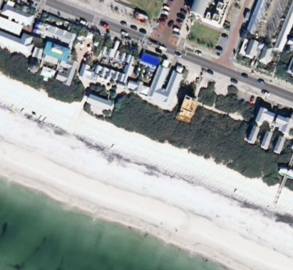
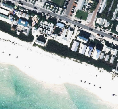
The selected borrow area offshore western Walton County is centrally located and contains the highest quality and most suitable borrow material identified by these reconnaissance and detailed sand source investigations. The study reviewed approximately 64 square miles of offshore area for geophysical compatibility in the reconnaissance phase. These results informed a detailed geotechnical sampling phase, which sampled over 50 vibracores (20 ft deep) from the borrow area for lab analysis [4]. Along the native beach, samples were collected every one mile at the dune vegetation, dune toe, mid-berm, MHW shoreline and MLW shoreline positions. The borrow area’s limits are designed to use sand specifically identified by these studies to meet the goals of the project and State, Federal, and local requirements for beach compatibility [1].
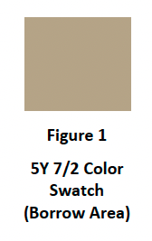
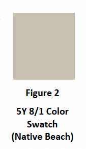
To summarize, engineers reviewed color, soil classification, grain size distribution, and shell content for sand compatibility between the borrow area design specifications and the native beach. The color of the borrow area acceptable color limit is described as Munsell color 5Y 7/2 or lighter for moist/wetted material while the native sand is described as Munsell color 5y 8/1 or lighter for moist/wetted material. The acceptable silt content for the borrow material is less than 2.5% and the native beach silt content is less than 0.3%. The acceptable borrow area carbonate content is required to be less than 5% and the native beach sand is less than 1.2%. The acceptable borrow area mean grain size range as the native beach mean grain size range of 0.24-0.48 mm [4]. A Sand Quality Control and Quality Assurance Plan requires the construction contractor to meet these thresholds and operations would be altered if sand placed on the beach is out of compliance [2].
The Corps provides context to how dredged materials will increase in compatibility with the native beach over time.
“Some discoloration of the sand would occur following placement due to the fact that the sands to be placed on the beach are coming from anaerobic environment. Natural bleaching of the sand should occur within one to two months. Rainfall and wave action would act to filter out the fine grained materials from the restored beaches and increase the compatibility of the nourishment sands with those presently on the beach. These impacts will be temporary and insignificant in nature” [1].